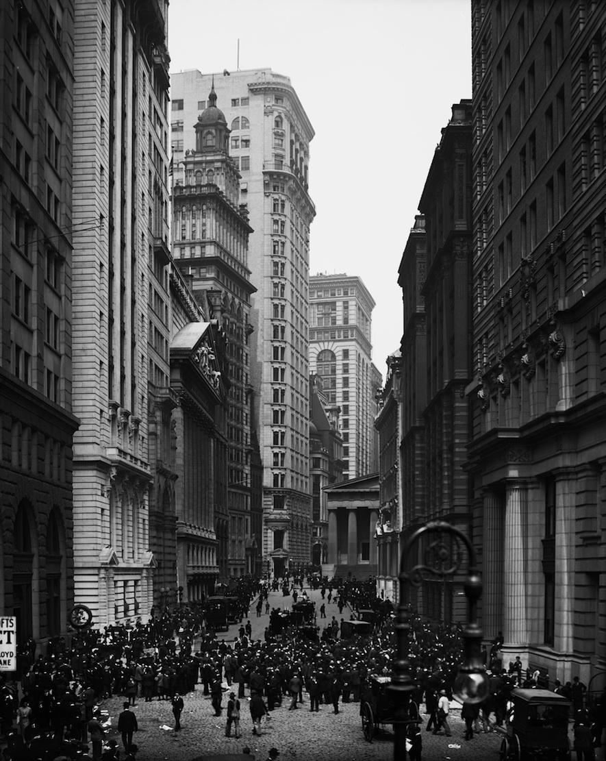
THE BROAD crossroads where Wall Street and Broad Street come together is a beautiful space, fully the equal of medieval European plazas. Today, post-911, it’s closed to almost all traffic, because the New York Stock Exchange sits at the southwest corner of the intersection. A few weeks ago, it was the symbolic center of the NYC DOT’s Shared Streets Lower Manhattan, when one Saturday afternoon 60 blocks were designated “shared spaces,” where “Pedestrians, cyclists, and motor vehicles will share the historic streets of Lower Manhattan and motorists [were] encouraged to drive 5 mph.”
When Americans talk about shared space, someone will often say, “We’re not Amsterdam.” Well, parts of Nieuw Amsterdam / New York City make a good place to start shared space experiments. Eighty per cent of Manhattan residents don’t own a car, and only twenty per cent of Manhattan workers commute to work by private car. Then add the fact that many streets in the Financial District have restricted access: some streets are only open to residents or workers employed on the street; while other streets have tank barricades and are only open to emergency and delivery vehicles.
In the real Amsterdam, 85% of the streets today have s speed limit of 30 kilometers per hour (18.6 mph), and the other 15% have a top speed of 50 kph (31 mph). On the slower streets, pedestrian and cyclist have as much right to the street as cars and trucks, and may be anywhere on the street at any time. All of the detritus of traffic engineering—bold stripes and arrows painted on the pavement, large signs, colored bus lanes, and the like—is missing, and at the intersections, there are no stop lights, stop signs, yield signs, or crosswalks. Motor vehicles must be driven at a speed that successfully allows cars and trucks to stop for pedestrians and cyclists in the intersection.
That is “Shared Space.” That is the spirit behind the experiment the DOT tried out on Saturday, August 13, and what it hopes to try again in the future. I hope they will and therefore I make Broad Street my Street of the Day. Some of the my notes on that continue below.
First, experimenting with Shared Space streets in New York City is an important and needed step. If grabbing land in Madison Square and introducing Vision Zero are the two most important things DOT commissioners in the US have done in the last fifty years (and I think they are), this could be number three.
Personally, I prefer to call them “Slow Streets,” because in the cycling world a number of bad British Shared Space designs built in the last few years have made Shared Space controversial there. Successful Shared Space depends on the cars going 20 miles per hour or slower, and the primary problem with the controversial British streets is that the designs allow the cars to go too fast. Whenever the topic of Shared Space comes up in the Twitterverse—and sometimes elsewhere—you can expect British cyclists to jump in with diatribes against Shared Space that hijack the conversation.
The defining characteristic of Slow Streets, however, is that the cars go slowly. And Slow Streets can naturally be part of Slow Zones, which New York already has. And Slow Streets and Slow Zones enable good placemaking and good urban design. More on this later.
Second, the Financial District is a great place to start, for all the obvious reasons: the police have already blocked many of the streets; traffic is already light and slow; the streets are often narrow and naturally slow; the streets are frequently narrow and picturesque; there are already lots of tourists in the area, with things for them to do; there is lots of food and drink in the area; there is lots of history in the area (that could be better managed); the intersection of Wall and Broad Streets is both historic and beautiful, the equal of places like the Via della Dogana Vecchia in Rome’s Centro Storico (a Shared Space); there are more great streets, great buildings, and historic sites nearby.
Broad Street was one of the two most important streets in Nieuw Amsterdam. At it’s top, on Wall Street, was the first US Capitol, where George Washington had his first inauguration. Catty corner stand the New York Stock Exchange and the House of Morgan, the two most emblematic symbols of “Wall Street,” itself the symbol of New York’s financial industry (the Morgan building, 23 Wall Street, has stood empty since 2008—it’s owned by a Chinese billionaire embroiled in scandal).
The space at Broad and Wall is beautiful.* The buildings that shape it are historic and beautiful. Trinity Church terminates the vista on the west, drawing pedestrian traffic to Broadway. To the east, is another great urban street, with great picturesque views like the deflected vista at the National City Bank Building (55 Wall Street). The NYPD has already pushed cars off both Broad and Wall Streets.
In terms of urban design, the New York Stock Exchange and the NYPD have brought problems with their security concerns. The fence running down the middle of Broad Street—in exactly the wrong place—looks like it was bought in a bargain sale at Home Depot. The tank barriers are obvious overkill that are bad for pedestrians and cyclists. Design can solve problems, and there are secure solutions that do not disrupt the street like the tank barriers. Civic Art and security are not necessarily in conflict with each other.
Urban designers frequently talk about A streets and B streets: A streets are the best streets for people, with or without cars; and B streets are those where cars dominate. The particulars of A streets and B streets can be analyzed and designated in many ways, but in terms of walkability, the simplest way is to walk the streets with maps and markers, marking the places where it is pleasant to be and the places that are unpleasant. This should be done quickly, without a lot of thought (the thought can come afterwards, when deciding how to use the findings). Tests have shown that if this is done with a large group of people, there will be a lot of overlap and agreement on the best and worst places.
Broad Street and Wall Street are obviously both A streets. The A Streets are the streets where people would walk the most, and they might have no parking. The B Streets, where people don’t want to walk, should have the most concentrated parking. There will be some blocks where one or both ends of the block might be A, while the middle of the block might be B. B Streets can be merely boring, not actually bad. An example is Beaver Street between Broadway and Broad Street. The middle is merely boring, particularly at night. Marketfield Street, perpendicular to Beaver in the middle of the block, is an alley that is clearly a B Street. Across Beaver from Marketfield is New Street, less bad, but still a B Street. Other parts of Beaver Street have stretches that are not pedestrian friendly, but these can be interspersed with historic sections. This is where judgement and design come in during the planning, balancing parking needs, historic sites, and the like.
The Shared Space / Slow Zone could begin with the entire sixty-block area used in the DOT’s Shared Space day, or it could start with a few blocks around Broad and Wall, where traffic is already banned, and be expanded over time. Tactical urbanism can be used, but even in the tactical urbanism there should be less engineering and more urban design. Engineering applies formulas such as Functional Classification street types and preferred forms of speed control devices. Urban design works with the context to solve problems and make places. This partly explains why engineers frequently say, “the devil is the details” (making the formula work), while architects and urban designers say, “God is in the details” (creating designs that make places).
In the end, traffic calming usually still prioritizes traffic flow and the car over walkability and placemaking: engineering formulas used to calm traffic are rarely the best solutions for maximizing walkability. The purpose of traffic calming devices such as speed bumps is to slow traffic. The purpose of the urban design elements I mention is to make places where people are safe and comfortable walking. Safety is not their primary purpose, but in making streets where cars must go under 20 mph and drivers know pedestrians and cyclists have equal right to the street, safety is greater than on most streets where cars going 25 mph and faster come into contact with pedestrians.
Some examples: “pinching” the entrance to the street is usually an engineering solution. Urban designers want to make the whole length of the street appropriate for the speed and a good place to be. Urban designers do not like White Plastic Sticks, which delaminate and yellow with age, looking cheap and unpleasant—especially up close and at walking speed. If it’s important to mark the entrance, iron bollards can do that more effectively than white plastic sticks, which can safely and with no penalty be hit and run over.
On streets with no parking, “bumpouts” should usually not be used to move the curbs in and out. What is important is the shape of “the space between the buildings,” and the easiest way to make that harmonious and comfortable is often to line things up: buildings, trees, sidewalks, bollards, etc. That’s not an absolute rule, but it can be a good place to start.
National retailers, who have determined to a fraction of a penny how different design elements affect their sales per square foot, are adamant that streetscapes should not be fancy, with many colors, materials, shapes, etc., because they want to make sure that pedestrians are looking at their windows, not at colored sidewalks or fancy benches. Similarly, what is important for the pedestrian is the harmony of the space, not a multi-color intersection that draws attention to the wrong place. Cars have the most conflicts at the intersections, but public life takes place between the buildings, not at the crosswalks at the intersections. Fred Kent at the Project for Public Spaces says “‘streetscape’ is a dirty word.”
The great Dutch traffic engineer Hans Monderman showed that Shared Space requires the removal of all the elements that make the driver comfortable going quickly: bright stripes, bold graphics, traffic signs, stop signs, stop lights, and even protected bike lanes. Conversely, the pedestrian’s limbic system understands that highway-scale graphics announce, “This is machine space—Stay Out!”
Better than traffic elements like “20 MPH” written in six-foot letters are design elements like cobblestone rumble strips. These can also replace speed bumps, which frequently inspire teenage boys to accelerate and brake hard between the bumps. They also make driving on the street an unpleasant experience.
Trees planted in permeable strips are a good way to narrow a street without the expense of moving the curbs. Many FiDi streets are not good candidates for majestic street trees, but some of the streets would work well with pollarded trees. We know now that these can grow well in Silva Cells and the like, but that they should never be put in tree pots, which makes them stunted and prone to disease. All of these suggestions are made in passing. Real decisions obviously require more time.
One thing that struck me during the Shared Space experiment was how many more people were over on Broadway than in the Shared Space zone. Something like a Freedom Trail could pull people into the Slow Zone, as well as beyond the intersection of Broad and Wall. Without looking at the numbers, one imagines that Ground Zero must be an enormous tourist draw. Many tourists also make it over to Broadway, and then to Broad and Wall, but most of the other streets seem to have far fewer tourists, despite the large number of bars and restaurants.
A trail that would take people through the Slow Zone and to the Battery and the harbor seems like a good, simple, and easily achievable idea, but the trail would require some management. Some of the special events organized by the NYC DOT for the Shared Space day should be there all the time (the band that wandered the streets was excellent). And I couldn’t help but think that many New Yorkers would be happy to see some of the Times Square tourists moved to the Financial District. Are there places downtown such as in buildings on Water Street with the underused arcades where the Disney or M&M stores would be less obnoxious than on the Great White Way? I think so.
Do many tourists realize that there is an Museum of American Finance at 48 Wall Street, or that the Customs House has the National Museum of the American Indian? Wouldn’t the Finance Museum be better in the House of Morgan? Perhaps it could be combined with a branch of the Museum of the City of New York, which has a great fifteen-minute show on the history of New York.
Back to the design of Shared Space and Slow Streets in Lower Manhattan: ddifferent countries in the West have approached the problem differently. The American solution, particularly the American solution that will work today in New York City is still evolving. Figuring out how to do that involves what Stanford calls “Design Thinking.”
Every country has discovered that safe, effective Shared Space requires that the car goes 20 mph / 30 kph or less. Much of the best shared space is in the Netherlands, like the streets in Amsterdam mentioned above. We need more streets that show New York is serious about reducing auto use and the automobile’s contribution to climate change.
Slow Streets don’t invite suburban drivers to bring their cars to the city, as our urban highways and one-way arterials do. Slow Streets favor pedestrian and urban life. When we remove all the striping and signs that mark the streets as machine space, it becomes easy to make streets where people want to be. Before the automobile, we even put stone monuments and fountains in our streets. Temporary monuments like the original Washington Arch, which was originally in the middle of the street, marking the beginning of Fifth Avenue, were common. New Yorkers felt free to step out into the street as they do in Amsterdam. That’s the essence of Shared Space.
* Neurocognitive testing, Visual Preference Surveys, City Satisfaction Surveys and the like show that beauty is one of the most important factors in making places where people want to walk.